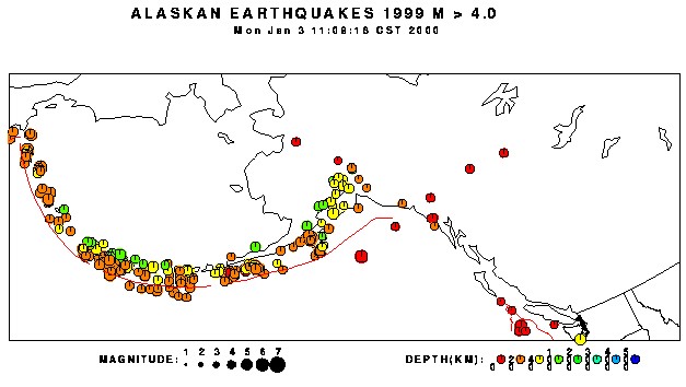
ALASKA EARTHQUAKE DANGERS
DREAMS TELL THE REAL STORY
compiled by Dee Finney
| 6-12-03 - DREAM - (I had this dream twice, but telling the problem
to different people with the same frustrating result - that I knew the problem,
but it was out of my hands to solve it and it freaked me out that I couldn't
personally do anything about it. Besides that, I think I've had this dream
before.)
I was working at A-C in my old job as purchasing secretary. The men with the real responsibility weren't there - they were on vacation and not reachable. I got a phone call from a machining company, telling me that we hadn't yet shipped them a stainless steel part - an impeller - so they couldn't machine it and they would be late to deliver it. (long time dreaming about impellers tells me that this is about a vortex) I told the man I would check on the part, see where it was and get back to him. I went to my bosses desk and pulled out the purchase order to find out exactly what part it was, then went to the pattern card file and got the pattern card where all the information for the pattern and casting is recorded as to who made the part. The pattern card had nothing written on it since 1964, which meant that the pattern hadn't even been looked at, much less moved either to a pattern shop, or a casting manufacturing place to make the part yet, much less shipped to the machining company. I would have to call all the pertinent companies myself to straighten out the mess since my boss was not available, but first I had to find out where the pattern was. My first husband came into the office and I tried to explain the problem to him, knowing he would understand as he worked for a company that made castings - in fact - I had personally shipped patterns to his company and he personally made some castings from my patterns. However, it was lunchtime and he had to leave and go back to work, so I walked out into the company yard with him. There was a huge concrete wall around the yard with a heavy concrete door which was opened by pulling on a cut-off tree branch. He went through the door and it closed, leaving me alone in the enclosure. When I went to open the door, I found that the tree branch was old and rotted and it broke off in my hands. So I reached up for a better grip and more of it broke off. Now there was nothing left to even grab hold of - so I pounded on the concrete door to try to get someone's attention and my fists against the concrete made absolutely no sound at all. But all was not lost - I had a bird there I thought I would tie a handwritten note to his foot and set him free and someone would see the note and come and find me locked in the concrete box of a yard when they found the bird. So I went to get the bird I would tie the note onto and the bird flew up into the air but its feet were caught on something and the bird rose into the air, leaving its feet behind. This so freaked me out - I woke up. I went back to sleep and was now again in the office and trying to explain the problem of the missing pattern not being moved since 1964 - the boss being on vacation and unreachable. The girl I was explaining it to had her own problems to deal with and was trying to call for help for that. Besides that, she had no responsibility for the problem of the pattern. Then I realized that it wasn't my problem either since I didn't even work there anymore. I felt so frustrated that I pounded on the wall like before and yelling "I want to go back to work," but I couldn't. I was too old and had already retired . I was so frustrated, I woke up.
|
| 6-13-03 - DREAM - I was looking at a map of Alaska - one of those
kind where you can see the mountains and the valleys and all the colors in
green and brown.
Then - on this map were 7 vortexes - 6 in a large circle and one in the center. These vortexes were set in place by electric wires and connected to each other. A group of men had done this. I couldn't actually see the connecting wires but I knew they were there - underground. I was determined to figure out how to disconnect them, because if something went wrong on one of the vortexes while they were connected, they would all go off at the same time and people would be killed.
|
PREVIOUS INFORMATION ABOUT ALASKA QUAKES 1-15-90 Meditation: The chain of mountains between Portland, Oregon and Alaska will all come to life and spew smoke, lava, and cause many earthquakes. NOTE: Since this meditation, Mount St. Helens, Mount Rainier, and Mount Baker, all in Washington State have been known to be blowing steam, Mount St. Helens has been blowing smoke, and areas both north and south of these three major mountains have been rocked with earthquakes on a continuous basis. Most of them are too minor to be felt, however in checking the records over the years, the evidence shows that these mountains will eventually blow like they have in the past.
|
| 4-21-92 - MEDITATION - I was raising my vibrations and watching doors
opening up and heard ' August 1st thru August 27th". I asked, "What is happening
then?" A. "This is the 1st time we will be starting an earthquake."
Actual result: An earthquake of M 4.2 occurred on August 26,1992 in Daixian,apart from Taiyuan about 140 km. An other earthquake of M 6.0 occurred on August 31,1992 in the margin of North China (East longitude1 10.3 degree ,North latitude 43.9degree). West of the Red Rock valley region, along the Montana-Idaho border, the frequency of recent seismicity decreases markedly. Only two events in the Leadore, Idaho region (figure 12) have sufficient data to permit fault-plane solutions. The 28 August 1992 earthquake is notable because of its lack of associated events and its magnitude of 4.0. The MS = 7.3 Suusamyr earthquake of 19 August 1992 was a large, thrust-type earthquake in the northern Tien Shan of Kyrgyzstan, an intracontinental mountain belt in central Asia. Mount Spurr in Alaska August 18 1992 eruption. The earthquake activity did not change in the days or hours before the eruption and scientists did not issue a specific warning before the eruption occurred. ]
|
| 10-24-92 - MEDITATION - Voice "We're looking for pictures." I saw
a book open up. There was Alaska on the top half of the page and Europe on
the bottom half. They were covered in black. The voice said, "The black means
they are covered over ... capped so to speak. " There were bright grooves
along the coastline going inward. I asked what that was. The voice said,
"That where the destruction is."
NOTE: The last large earthquakes in Alaska were in 1957, 9.1; 1964, 9.2; 1965, 8.7. The large quake in Alaska moved the land towards the coastline by 70 feet. It caused millions of dollars in damage as the quake not only damaged buildings and land, but it caused a huge tsunami which came back in and slammed every building and pieces of debris which destroyed many other buildings as well. The earthquake was felt over approximately 7,000,000 square mile of Alaska, and portions of the Yukon Territory and Canada. The tsunami wave left serious damage along the Gulf of Alaska, Canada, Hawaii and the West Coast of the United States. In Europe, most of the other quakes occur in the Alpine belt, which cuts across Europe and Asia from Burma to southern Europe and North Africa. This prophecy follows along with the previous one from 7-24-89 where France, Spain, and Portugal were given. In the book of Isaiah, Chapter 24, a similar prophecy was given against Tyre in Egypt. If one looks at a map, it follows the same earthquake fault and is directly across the narrow mediterranean from Europe. "The earth is completely broken down; the earth is totally rent—the earth is moved exceedingly. The earth shall reel to and fro like a drunkard, and shall be removed like a cottage; and the transgression thereof shall be heavy upon it; it shall fall, and not rise again. And it shall come to pass in that day, that the Eternal shall punish the host of the high ones that are on high, and the kings of the earth upon the earth. They will be gathered together as prisoners in a pit; they will be shut up in a prison, and after many days they will be punished. Then the moon will e confounded, and the sun ashamed; for the Lord of hosts will reign on Mount Zion and in Jerusalem and before his elders he will manifest his glory." (Isaiah 24:19-23).
|
| 12-1-98 - DREAM - I was seeing a series of maps of the United States,
Alaska, and Canada. I was shown various types of maps with all the states
marked, each section map like Northeast, midwest, western, then other kinds
of maps like topography, and other kinds of separations.
I didn't see any disaster or anything, just all the various separations of many kinds.
|
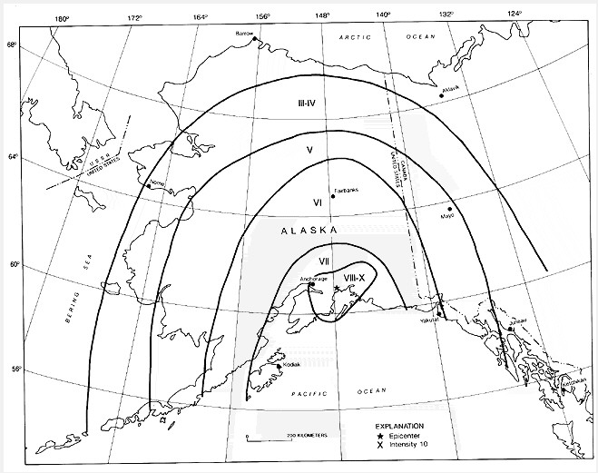
THE QUAKES OF THE PAST |
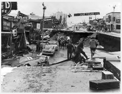
| THE 1964 QUAKE
Prince William Sound, Alaska 1964 March 28 03:36:14 UTC (March 27 local), Magnitude 9.2
This great earthquake and ensuing tsunami took 125 lives (tsunami 110, earthquake 15), and caused about $311 million in property loss. Earthquake effects were heavy in many towns, including Anchorage, Chitina, Glennallen, Homer, Hope, Kasilof, Kenai, Kodiak, Moose Pass, Portage, Seldovia, Seward, Sterling, Valdez, Wasilla, and Whittier.
Isoseismal Map Damage photos from earthquake
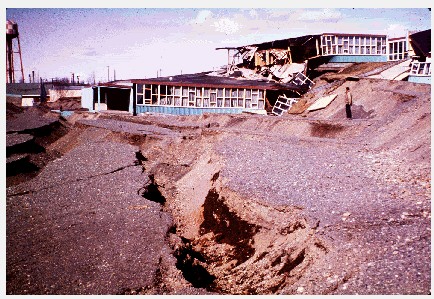
alaska school - anchorage Uplifted sea floor at Cape Cleare, Montague Island, Prince William Sound, in the area of greatest recorded tectonic uplift on land (33 feet). The very gently slopping flat rocky surface with the white coating which lies between the cliffs and the water is about a quarter of a mile wide. It is a wave cut surface that was below sea level before the earthquake. The white coating consists of the remains of calcareous marine organisms that were killed by desiccation when the wave cut surface was lifted above the high tide during the earthquake. A subsidence trough (or graben) formed at the head of the "L" Street landslide in Anchorage during the earthquake. The slide block, which is virtually unbroken ground to the left of the graben, moved to the left. The subsidence trough sank 7 to 10 feet in response to 11 feet of horizontal movement of the slide block. The volume of the trough is theoretically equal to the volume of the void created at the head of the slide by movement of the slide block. A number of houses seen in this photograph were undercut or tilted by subsidence of the graben. Note also the collapsed Four Seasons apartment building and the undamaged three story reinforced concrete frame building beside it, which are on the stable block beyond the graben.
Trees up to 24 inches in diameter and between 88 and 101 feet above sea level were broken and splintered by the surge wave generated by an underwater landslide in Port Valdez, Prince William Sound.
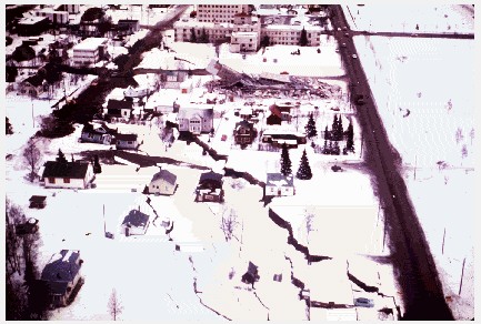
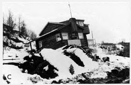
The Turnagain Heights landslide in Anchorage, occurred along a steep bluff fronting Knik Arm of Cook Inlet. Its length, which is parallel to the bluff, was about 1.5 miles; its width was about .25 to .50 miles. This landslide reduced to rubble many of the finer homes of the city. Failure here, and in the "L" Street, Fourth Avenue, and Government Hill landslides in Anchorage occurred on horizontal or near horizontal slip surfaces in the Bootlegger Cove Clay, a marine silt of Pleistocene age. Alaska.
Anchorage, about 120 kilometers northwest of the epicenter, sustained the most severe damage to property. About 30 blocks of dwellings and commercial buildings were damaged or destroyed in the downtown area. The J.C. Penny Company building was damaged beyond repair; the Four Seasons apartment building, a new six-story structure, collapsed; and many other multistory buildings were damaged heavily. The schools in Anchorage were almost devastated. The Government Hill Grade School, sitting astride a huge landslide, was almost a total loss. Anchorage High School and Denali Grade School were damaged severely. Duration of the shock was estimated at 3 minutes. Landslides in Anchorage caused heavy damage. Huge slides occurred in the downtown business section, at Government Hill, and at Turnagain Heights. The largest and most devastating landslide occurred at Turnagain Heights. An area of about 130 acres was devastated by displacements that broke the ground into many deranged blocks that were collapsed and tilted at all angles. This slide destroyed about 75 private houses. Water mains and gas, sewer, telephone, and electrical systems were disrupted throughout the area. The earthquake was accompanied by vertical displacement over an area of about 520,00 square kilometers. The major area of uplift trended northeast from southern Kodiak Island to Price William Sound and trended east-west to the east of the sound. Vertical displacements ranged from about 11.5 meters of uplift to 2.3 meters of subsidence relative to sea level. Off the southwest end of Montague Island, there was absolute vertical displacement of about 13 - 15 meters. Uplift also occurred along the extreme southeast coast of Kodiak Island, Sitkalidak Island, and over part or all of Sitkinak Island. This zone of subsidence covered about 285,000 square kilometers, including the north and west parts of Prince William Sound, the west part of the Chugach Mountains, most of Kenai Peninsula, and almost all the Kodiak Island group. This shock generated a tsunami that devastated many towns along the Gulf of Alaska, and left serious damage at Alberni and Port Alberni, Canada, along the West Coast of the United States (15 killed), and in Hawaii. The maximum wave height recorded was 67 meters at Valdez Inlet. Seiche action in rivers, lakes, bayous, and protected harbors and waterways along the Gulf Coast of Louisiana and Texas caused minor damage. It was also recorded on tide gages in Cuba and Puerto Rico. This great earthquake was felt over a large area of Alaska and in parts of western Yukon Territory and British Columbia, Canada. Aftershock Distribution There were 52 larger aftershocks which were heavily concentrated on the northeast and the southwest of the uplifted region (USC&GS, 1964), (which was also the tsunami generating region). The largest had a magnitude of 6.7. The first 11 of these aftershocks, with magnitude greater than 6.0 on the Richter scale, occurred in the first day; in the next three weeks there were 9 more of similar magnitude. Aftershocks continued for more than a year. Thousands of such smaller aftershocks were recorded in the months following the main earthquake. The aftershock zone of the Great Alaska Earthquake was about 250 km wide and extended from about 15 km north of Valdez in Prince William Sound for 800 km to the SW end of Kodiak Island to about 55 km. south of the Trinity Islands. The main shock and its aftershocks occurred on a fault which marks part of the boundary between the Pacific and North American tectonic plates. Area Over Which the Great Alaska Earthquake Was Felt: The earthquake was the strongest ever felt in North America. The area over which it was felt encompassed approximately 1,300,000 km2 (all of Alaska,parts of western Yukon Territory and British Columbia, Canada and the State of Washington). Horizontal Displacements: As a result of the 1964 earthquake quake, the net horizontal movement of the Pacific plate under the North American plate was about 9 meters on the average in a southeast direction, although some sections apparently moved considerably more. For example, Latouche Island area moved about 18 meters to the southeast. Uplift and Subsidence: The earthquake caused vertical displacements which ranged from about 15 meters of uplift to 2.3 meters of subsidence relative to sea level. Patterns of uplift and subsidence which had been slowly developing prior to the earthquake were suddenly reversed. For example, average uplift at Montague Island was 4-9 meters while off the southwest end of the island, there was vertical displacement ranging around 13 - 15 meters. Uplift also occurred along the extreme southeast coast of Kodiak Island while at Women's Bay, on the same island, subsidence of 1.7 meters was measured from tide gauges datum. Sitkalidak Island, and over part or all of Sitkinak experience uplift while areas around Portage subsided by as much as 3 meters. Other areas had no change. The zero line (line of no vertical change separating the uplift and subsidence zones) extended from near the epicenter in Prince William Sound to the SE coast of Kodiak Island. The zone of subsidence covered about approximately 285,000 square kilometers. It included the the west part of the Chugach Mountains, the north and west parts of Prince William Sound, most of Kenai Peninsula, and almost all the Kodiak Island group, all the way to Trinity islands. ONE MAN'S PERSONAL EXPERIENCE (WITH PHOTOS) |
Andreanof Islands, Alaska 1957 8.8 Andreanof Isl., Aleutian Is., Alaska - 1996
|
|
| Kenai
Peninsula, Alaska - May 5, 1999 - Magnitude 5.6 (Mb)
The following is from the United States Geological Survey, National Earthquake Information Center: preliminary hypocenter for earthquake of 1999 may 27, SOUTHEASTERN ALASKA, about 55 miles (90 km) WNW of Gustavus, Alaska: latitude 58.7 degrees north longitude 137.2 degrees west origin time 08 08 58.2 utc depth shallow, magnitude 5.2 mb. >> Kodiak Island Region, Alaska - May 7, 1999 - Magnitude 6.1 (MS) Earthquake in the Kodiak Islands Region of Alaska December 6, 1999 Magnitude 7.0 Mw Southeastern Alaska - January 06, 2000
|
May 2, 2000, BC-Yukon Border 5.3
|
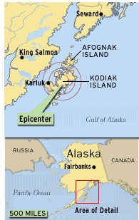
Alaska Earthquake Magnitude 6.5 Quake Rocks Kodiak Island A magnitude 6.5 earthquake shook Kodiak Island in Alaska on Monday evening. The quake was centered on the island's west coast, about 80 miles west of Kodiak and near the village of Karluk. There were no reports of injuries. (Art Today) July 11 , 2000— A magnitude 6.5 earthquake shook Kodiak Island in Alaska on Monday evening, causing minor damage at a Coast Guard station on the island, the Alaska Tsunami Warning Center said. The earthquake did only minor damage to the sparsely populated island. (ABCNEWS.com/ Magellan Geographix) The quake, recorded at 5:32 p.m., local time, was centered on the island’s west coast, about 80 miles west of Kodiak and near the village of Karluk. There were no reports of injuries. “It was felt strongly at Kodiak and King Salmon and it was also felt throughout Southern Alaska and as far North as Fairbanks,” said Trina Vithayathil, a geophysicist with the U.S. Geological Survey in Golden, Colo. Only minor damage was reported. There were reports of “some broken pipes in residences on the Coast Guard base on the east side of Kodiak Island,” geophysicist Bruce Turner said. The quake was located about 288 miles southwest of Anchorage. Karluk is a village of less than 100 people, Turner said. Vithayathil said no tsunami warning has been issued. “There’s no tsunami warning or watch that’s been put out and there’s no expectations of a tsunami,” Vithayathil said. ABCNEWS Radio and The Associated Press contributed to this report.
|
| ALASKA QUAKE
AN EARTHQUAKE, PRELIMINARY MAGNITUDE 6.9, OCCURRED AT 1413 AST ON DEC 6, OR 1513 PST ON DEC 6, OR 2313 UTC ON DEC 6. THE EARTHQUAKE WAS LOCATED 310 MILES SW OF ANCHORAGE, AK. OR 65 MILES SW OF KODIAK, AK. AT 57.4N, 154.3W NOAA TSUNAMI BUOY ‘FEELS' ALASKA EARTHQUAKE January 11, 2001 — A magnitude 6.9 earthquake occurred at 11:03 a.m. EST Wednesday morning about 70 miles southwest of Kodiak, Alaska. NOAA's tsunami warning centers located the position of the earthquake, assessed its magnitude, and issued an information bulletin minutes later. A few minutes after the warning was issued, a NOAA tsunami detection buoy picked up the earthquake waves that displaced the seafloor instrument that triggered the buoy to start transmitting 1 minute data. At that time these data were plotted on the centers' Web site. "The detection buoy, located off the Alaskan coast, performed as designed in detecting an abrupt change in sea level and sending data via the NOAA GOES satellite to the NOAA tsunami warning centers and to its Pacific Marine Environmental Laboratory in Seattle where these data were plotted on a Web site. Anyone on the Web could view these data 10 minutes after the earthquake ruptured," said Eddie N. Bernard, director of NOAA's laboratory in Seattle, Wash. "More important, the data showed that no tsunami was generated either by the earthquake or an underwater landslide induced by the earthquake." Charles McCreery, geophysicist in charge of the National Weather Service's Pacific Tsunami Warning Center, one of two such centers—the other is in Alaska—said, "While the earthquake was too small to automatically trigger a tsunami warning, the Pacific Tsunami Warning Center closely monitored the Kodiak buoy data to quickly confirm that potentially destructive tsunami waves were not propagating towards Hawaii or the rest of the Pacific." The buoy is part of the Deep-ocean Assessment and Reporting of Tsunamis or DART project, which offers early detection of tsunamis and for assessing and forecasting the threat to coastal communities. DART also reduces false alarms that undermine the credibility of the warning system and are extremely expensive; 75% of all warnings issued since 1948 have been false, and the evacuation of Honolulu in 1986 cost more than $30 million. The Pacific Marine Environmental Laboratory has developed a system that acoustically transmits data from a Bottom Pressure Recorder (BPR) to a surface buoy, which then sends the data to shore-based receivers through a satellite communications link. The BPR research experience over the last 10 years indicates that these real-time systems are capable of detecting deep ocean tsunamis with amplitudes as small as 1 cm. A prototype system was fabricated, tested, and successfully deployed for two months off the Washington-Oregon coast in 1995. There are now four buoys located from the Aleutian Islands to the Washington-Oregon coast. A tsunami is a series of ocean waves generated by any rapid large-scale disturbance of the sea water. Most tsunamis are generated by earthquakes, but they may also be caused by volcanic eruptions, landslides, undersea landslides, or meteor impacts. Tsunami is a Japanese word, represented by two characters: tsu meaning "harbor" and nami meaning "wave." Tsunamis rank high on the list of natural disasters. Since 1850 alone, tsunamis have been responsible for the loss of more than 120,000 lives and billions of dollars of damage to coastal structures and habitats. Tsunami waves radiate outward in all directions from the disturbance, and can propagate across entire ocean basins. For example, an earthquake in Chile caused a tsunami across the Pacific in Japan. Tsunami waves are distinguished from ordinary surf waves by their great length, often exceeding 100 miles in the deep ocean, and by the long amount of time between successive peaks—five minutes to an hour. The speed at which tsunamis travel depends on the ocean depth. A tsunami can exceed 500 mph in the deep ocean but slows to 20 or 30 mph in the shallow water near land. In less than 24 hours, a tsunami can cross the entire Pacific Ocean. In the deep ocean, a tsunami is barely noticeable and will only cause a small and slow rising and falling of the sea surface as it passes. Only as it approaches land does a tsunami become a hazard. As the tsunami approaches land and shallow water, the waves slow down and become compressed, causing them to grow in height. In the best of cases, the tsunami comes onshore like a quickly rising tide and causes a gentle flooding of low-lying coastal areas.
|
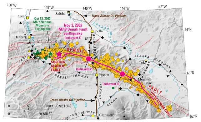
| M
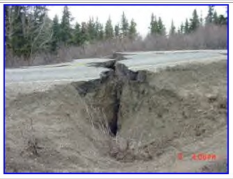
7.9 Denali fault event of November 3, 2002
... of the Denali fault, which is marked here by a prominent linear valley along the southern edge of the Alaska Range. The magnitude 7.9 earthquake that occurred ...
Monday, November 4, 2002 Alaska earthquake felt in Louisiana NEW ORLEANS - When people saw water sloshing about in ponds, bayous and pools, an earthquake more than 3,000 miles away seemed an unlikely culprit. "My neighbor actually thought there was an alligator in the pond," said Dan Musmanno, 51, of the New Orleans suburb Belle Chasse. "My neighbor's son went out there and said, 'It ain't no alligator.' The water was going back and forth for about a half hour. It was kind of spooky." Musmanno said the waves in his pond came up 7 or 8 inches and water sloshed out of his pool from what geophysicists say was the awesome power of a 7.9 magnitude earthquake that rocked a remote area of interior Alaska early Sunday afternoon. Posted 11/4/2002 3:12 AM Alaska earthquake shuts down pipeline ANCHORAGE (AP) — A violent earthquake slammed a remote area of Alaska's interior, delivering a jolt so strong that it created waves on lakes and ponds around the continent. The magnitude 7.9 quake was one of the strongest ever recorded in the United States. A rescue worker stands by a crack in Parks Highway caused by a 7.9 earthquake that rocked a sparsely populated area of Alaska. By Jimmy Tohill, AP The quake, centered on the Denali Fault 90 miles south of Fairbanks, struck Sunday at 1:13 p.m. Alaska Standard Time (5:13 p.m. ET) — its effects strongly felt in Anchorage about 270 miles to the south. It lasted at least 30 seconds. "It shook so bad you could not stand up on the front porch," said Jay Capps, a grocery store owner between Tok and Glennallen in the southeastern part of the state. "It sounded like the trees were breaking roots under the ground." Only one minor injury was reported, but the quake did considerable damage to Alaska's infrastructure. The temblor opened 6-foot cracks in highways and roads, shook homes and damaged supports to the Trans-Alaska Pipeline. Officials manually shut down the pipeline after the quake, and it was still out of service Monday. The oil flow can be manually stopped for maintenance or other reasons without affecting oil deliveries. The quake created a ripple effect thousands of miles away — from the bayous of Louisiana to lakes in the Seattle area. In the New Orleans area — more than 3,000 miles away — residents saw water slosh about as a result of the quake's awesome power. In Mandeville, La., Carol Barcia, 47, saw boats bounce around from the deck of her house. "One poor guy across the canal from us fell off his sailboat," she said. On Seattle's Lake Union, more than 1,400 miles south, waves shook some houseboats loose from their moorings and slammed them into docks. At least one boat sustained thousands of dollars in damage. Experts say such an effect is common during powerful quakes. "This earthquake was shallow and the energy went directly into the surface and that is what causes these effects so far away," said Dale Grant, a geophysicist with U.S. Geological Survey's National Earthquake Information Center in Golden, Colo. Grant said he received calls from nuclear power facilities in various states, including Minnesota and Washington, that reported unusual water movement. Bruce Turner of the West Coast and Alaska Tsunami Warning Center said the earthquake did not generate a tsunami. Numerous roads developed wide cracks, including the Alaska Highway near Northway, about 250 miles southeast of Fairbanks. The Richardson Highway, which parallels the pipeline between Valdez and Fairbanks, was closed near Paxson after gaps opened that were 2-to-6 feet wide and 5 feet deep, Wilkinson said. About 20 miles north, the ground on one side of the highway had dropped more than 2 feet. The worst reports of damage were along a two-mile stretch of the Tok Cutoff, where numerous rock slides and hundreds of yards of 6-foot openings in the road could be seen. Fuel tanks were knocked over in Slana, a village with no electric utility. Families use diesel fuel to power generators. Randy Schmoker, a metal worker in Porcupine Creek, was in his shop when he felt the ground move. "I thought, 'Oh good, an earthquake,' and then it got worse and worse," he said. Mike Heatwole, spokesman for the Alyeska Pipeline Service Co., said officials would know by midmorning Monday how long it will take to restart the pipeline. He did not know whether North Slope crude oil deliveries would be disrupted. Earthquakes above magnitude 7 are considered major — capable of widespread, heavy damage. In 1964, the "Good Friday" earthquake left 131 people dead in Alaska. Current measurements put that quake's magnitude at 9.2. Moderate earthquakes also shook the U.S. Midwest, Indonesia and Pakistan earlier Sunday, but the activity is not related nor unusual, said Waverly Person, geophysicist at U.S. Geological Survey. "On any given day, we located about 50 earthquakes throughout the world," Person said. "This to us is pretty normal." Copyright 2003 The Associated Press. All rights reserved
|
| Strong quake rattles Alaska
Thursday, October 31, 2002 FAIRBANKS, Alaska (CNN) -- A strong earthquake with a preliminary magnitude of 6.7 rocked Alaska early Wednesday, but little damage and no injuries were reported. The quake happened at 3:27 a.m. local time (7:27 a.m. EDT), and its impact was felt from Anchorage to Fairbanks, the Alaska Earthquake Information Center said. Its epicenter was about 95 miles south of Fairbanks, near Cantwell around Denali National Park. There are some reports from Fairbanks that some things were knocked off of shelves, [and] we have one report right now that the phone service to Denali National Park is down. -- Pete Petram, emergency management specialist for Alaska's Emergency Services Division No injuries have been reported, said Pete Petram, an emergency management specialist for Alaska's Emergency Services Division. "There are some reports from Fairbanks that some things were knocked off of shelves, [and] we have one report right now that the phone service to Denali National Park is down," Petram said. According to Alaska's Earthquake Information Web site, Alaska has the greatest earthquake and tsunami potential in the entire United States. Petram said officials aren't concerned about a tsunami -- a large ocean wave that can occur after an earthquake or volcanic eruption -- from Wednesday's quake. "The earthquake is far enough away from any body of water that a tsunami would not be generated," Petram said. The quake "was probably about 250 miles away from any ocean."
|
| Relevant Web Sites NOAA's Tsunami Research Program NOAA's Pacific Tsunami Warning Center NOAA's National Tsunami Hazard Mitigation Program NOAA's Tsunami Database NOAA's Tsunami Data from NOAA's National Geophysical Data Center Tsunami Damage Photos NOAA's National Weather Service Forecast Office, Honolulu, Hawaii NOAA Weather Radio Media Contacts: Jana Goldman, NOAA Research, (301) 713-2483 ext. 181 |
| EARTHCHANGES -
QUAKES
GORDA RIDGE - OREGON/WASHINGTON PACIFIC NORTHWEST - QUAKE LIST PUBLIC SEISMO NETWORK - ALASKA THE NEXT EARTHQUAKE IN ALASKA COULD COME SOONER THAN YOU THINK Seattle Earthquake - Feb. 28, 2001 DREAMS, PROPHECY AND NEWS OF VOLCANOES ... The aurora also has a strange pulse to it. Some very interesting experiments were conducted some decades ago by scientists from the University of Alaska. ... It was discovered too that geomagnetic activity could cause a change in air pressure over Alaska ... Alaska, No Longer So Frigid, Starts to Crack, Burn and Sag 6-17-02 ANCHOR POINT, Alaska, — To live in Alaska when the average temperature has risen A LITTLE ICE AGE - THE BROKEN TREE OF LIFE ... In Alaska, although 63 percent of the 200 glaciers measured were retreating, seven percent were advancing and 30 percent were holding their own. ...
|
DREAMS OF THE GREAT EARTHCHANGES - MAIN INDEX
|