THE TAIL OF THE TURTLE WILL SNAP
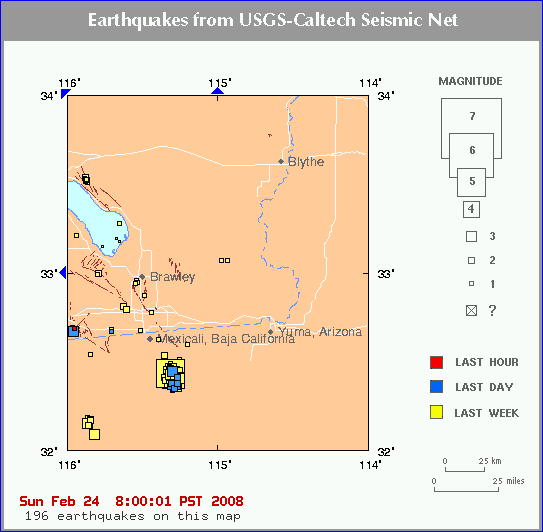
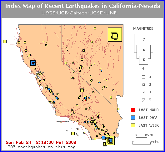
NEW QUAKES - 4-4-10
updated 2-18-11
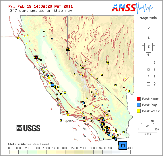
2-18-11 - 5.1 quake
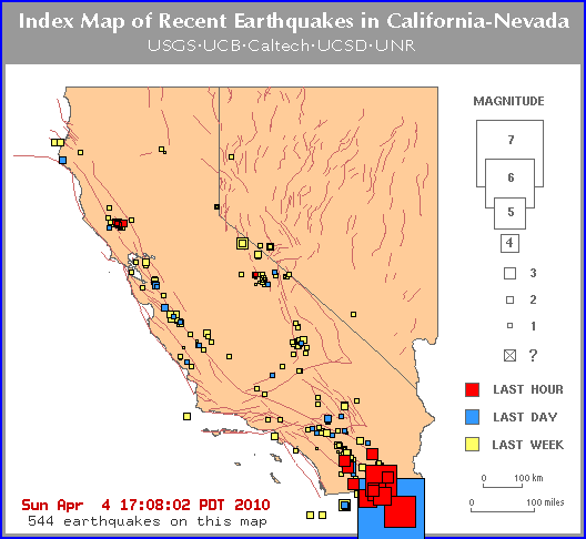
see previous quake swarms below
A swarm of larger earthquake has hit this area in
the last couple weeks.
The quakes in blue are 3.6
[ Dreams/Visions/Prophecy ] [ Main Menu ]
From: Hannah//Or, [DNS_Address]
Subject: The tail of the turtle will snap
| I heard this about an hour ago. Any clues? Was meditating on the loss symptoms my friend and I just experienced and the massive loss that will be occurring when I 'heard' this. |
From: Dee Finney, [DNS_Address]
Subject: Re: The tail of the turtle will snap
| Hello all: Some time ago, I had
a prophetic dream about Turtle Island you might be interested in
reading about. Wondering if the tail of the turtle is
Florida? I've had a dream some time ago about Florida snapping off of its current location and moving north along the gulf coast. Hard to figure out how that could happen though. http://www.greatdreams.com/lessons/turtle.htm Dee NEW DREAM - 2-23-08
Q. Dear
Prophecykeepers... what is the prophecy concerning the volcanoes in
the Northwest and their long prophesied "order of
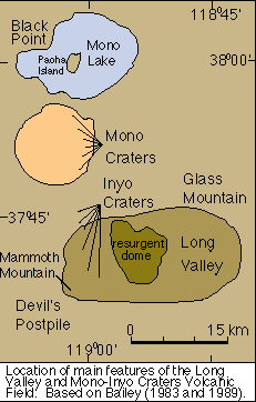
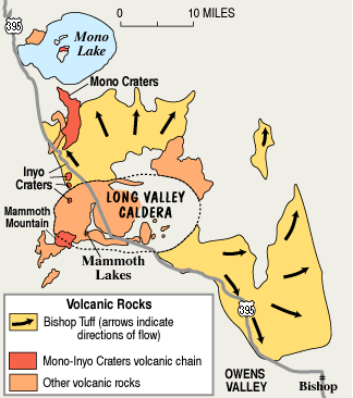
eruption" that will signal the worldwide earth changes? excerpted from: http://www.prophecykeepers.com/faqs.html THE LONG VALLEY CALDERA: in eastern California,
near Long Valley, which I wrote about in the Ninth Thunder Prophecy
; is what should be watched closely. The rapid build up in that
region most likely will lead to eruption very soon, leading to the
closing off of pressure valves along the cascades. Remember the
Elders always stayed close to the vision that "The Tail of the
Turtle would break. When these things occur, and the Turtles tail
begins to heave, and break up we will know the time is near."
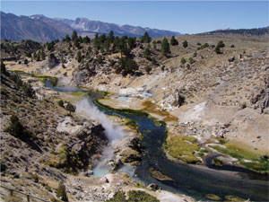
USGS scientists along with our colleagues at the U.S. Forest Service have published a new Fact Sheet, Boiling Water at Hot Creek - The Dangerous and Dynamic Thermal Springs in California's Long Valley Caldera. The Fact Sheet was written in response to safety concerns regarding recent hot spring activity and geysering in Hot Creek Gorge. Due to the unpredictability of the hazardous spring activity, the U.S. Forest Service has closed parts of the Hot Creek Geologic Site. Fact Sheet 2007-3045 explains why the previously popular swimming area is thermally unstable. Excerpted from: http://lvo.wr.usgs.gov/
From: http://volcano.und.edu/vwdocs/volc_images/north_america/california/long_valley.html
|
From: MCYoung/Tx, [DNS_Address]
Subject: Hannah...Re: The tail of the turtle will snap
| "BTW:: didn't you dream
about some tail of the turtle vision? Know where it would be
geographically speaking? See post below yours." Yes, many times. It was Old Woman who has said "The Tail of Turtle Will Be Broken." Then in a later dream she said it had alread begun. The location of the Tail of the Turtle(ie. Turtle Island which is North America)is said to be the Yucatan Peninsula of Mexico. Others have thought it could be the Baja but I have personally thought it is the thin piece of land that connects Central America with South America. I think this area because of the tectonic plates(Cocos iirc) in that region and the plausability of the land breaking or sinking there as a result. |
From: Kate in AZ, [DNS_Address]
Subject: I just assumed you're dreaming of the Galapagos!
URL: http://earthquake.usgs.gov/eqcenter/recenteqsww/Quakes/us2007ewap.php
From: MCYoung/Tx, [DNS_Address]
Subject: Hi Kate...Re: I just assumed you're dreaming of the Galapagos!
Well, after a lot of research
and help from others I became convinced the "Tail of the Turtle"
that Old Woman was speaking of was indeed in that area: |
From: Viz, [DNS_Address]
Subject: Re: Hannah...Re: The tail of the turtle will snap
| If we are talking about Native North American material here, then I think you should look further North. The heart of Turtle Island is another island within the island of North America. Up here in Ontario, we have a place called Manitoulin. It is an island, but also part of an archipelago of islands that divide Georgian Bay from Lake Huron. This archipelago or spine of rocks is actually the Niagara Escarpment. Manitoulin is a sacred place. Check your Ojibwa sources. This omen is troublesome to me. |
From: Hannah, [DNS_Address]
Subject: Re: Hannah...Re: The tail of the turtle will snap
| I'll look up what you suggested. I am troubled because lately these whispers have been for actual places or events. When I do get them in my non native tongue i pay attention. |
From: MCYoung/Tx, [DNS_Address]
Subject: Hi Viz...Re: The tail of the turtle will snap
| Oh my! That's new info for me.
I was going by the Hopi and other Native oral historys. Also because
the original message in which I was told this by "Old Woman" was in
the context of a sequence of events involving southern california.
At the time I had no idea there was a legend about Turtle Island nor that in SoCal there were actual faults and locations with the names I was being told. I will indeed have a look at the information to which you are referring...and am certainly not ruling it out. peace mc |
From: Hannah, [DNS_Address]
Subject: Re: Hannah...Re: The tail of the turtle will snap
| Hmmm. thanks MC. Interesting about the word that I heard being snap vs broken. Might be just a shaking leading up to the break. |
From: MCYoung/Tx, [DNS_Address]
Subject: Hannah...Re: The tail of the turtle will snap
| Or maybe Viz is onto something and an event will occur in TWO places? |
From: kemokae, [DNS_Address]
Subject: Re: The tail of the turtle will snap
| Supposedly that's when Mexico City gets their biggie quake and the tip of it splits off the mainland. Yes, there's millions of people that live in Mexico City and as I've said before it sits on the "San Andres" of the south, directly on top of it, with a huge volcano that overlooks it all. |
From: MCYoung/Tx, [DNS_Address]
Subject: Hi Kemokae...Re: The tail of the turtle will snap
| Yes, I think it was you who
first told me about this iirc. I've learned so much from you about
many things and consider you a true treasure on these boards. Thank
you! peace mc |
From: Hannah, [DNS_Address]
Subject: Re: The tail of the turtle will snap
| I think I might have gotten Mexico when I heard the word tortuga (sp). I asked hubby and he said it is the phrase used in Mexico to refer to turtle. |
From: MCYoung/Tx, [DNS_Address]
Subject: Hannah...Re: The tail of the turtle will snap
| If you remember there was a 7+ quake in Mexico a few years back and it was felt here in San Antonio. Anyway, it was after that quake that Old Woman told me "The Tail of the Turtle will be broken...it has already begun." I took this to mean the quake in Mexico was the beginning of the series of quake events in the ring of fire and along the west coast culminating in southern California. |
From: Jean in E OR, [DNS_Address]
Subject: Re: The tail of the turtle will snap
| Hannah, I heard several years ago that the tail of the turtle will be broken. At the time I felt that meant Panama. America was Turtle Island to the native peoples, if you look at her on the map, the head is near New England, Florida is a leg, Texas is too, Vancouver-Seattle area is a leg...maybe I've gone too far with this, but anyway, the tail goes down into Central America. What do you think? Blessings, Jean |
From: Hannah, [DNS_Address]
Subject: Thanks Jean
| I'm only going on instinct right now, but based on the language I was given in the second whisper, I'd say Mexico, either Gulf or Mexico city. Not sure weather either of these is a tail because I felt I was looking at ink spots and drawing to a blank movie screen. Might be I'm a little too tired to see. |
From: eiluj, [DNS_Address]
Subject: Isn't there something in one of the (probably) Hopi prophecies?
| Don't know if it was the tail of the turtle ... or the head of the turtle ... or something else about the turtle.... |
From: Hannah, [DNS_Address]
Subject: Re: Isn't there something in one of the (probably) Hopi prophecies?
| I'll google Hopi..oddly I got the message in spanish as well a little later on. The last few major life loss events have been preceeded by being told a message in a language I'm not fluent in. The first time it happened was a sign on an embassy. |
Native American Prophecies
Many people feel the birth of the Rainbow Family was foretold many, many years ago by various Native American tribes. Unfortunately, all of these tales are Oral Histories, so the specifics vary from version to version. About all we can do is compare the versions, and try to get the basic "feel" of the prophecy.Warriors of the Rainbow
-
This prophecy is the one that has become famous as it fortells the
birth of the "Rainbow Warriors", who will save the earth from
environmental destruction. Many people feel that we are these Rainbow
Warriors.zzzzzzz
-
The Rainbow Warrior - A short story about what it means to be a "Rainbow Warrior". This version comes from a farm in Ohio.
- Warriors of the Rainbow
- This version comes to us from Lelanie FullerAnderson "The Cherokee Lady", who has published severalbook on Indian Herbal Medicine. This version she says was told to her as a young girl by hee Grandmother.
- I have a new book on kindle - "The Warriors of the Rainbow"
Thanks Lelanie - web site ; http://www.angelfire.com/ok/TheCherokeeLady/index.html
- personal email
gwylady@sstelco.com
Lakota Sioux Prophecies
- Black Elk's Vision
- This is a summarization of Black Elk's vision as retold in the book "Black Elk Speaks". This talks alot about "Rainbows". and the Rainbow Tribe of many colors.
Hopi Prophecies
-
The Hopi prophecies are probably the most famous, as they talk about
the "Age of Purification", and there are many people that
believe the signs foretold in this prophecy have happened in the last 50
years or so.
- Frank Waters Version
- This is probably the best known version of the Hopi Prophecy. This is the version with that talks about the emergence of the Rainbow Family. It goes "...This is the Eight Sign: You will see many youth, who wear their hair long like my people, come and join the tribal nations, to learn their ways and wisdom...."
- Thomas Banacyca Translation
- This is the version by Thomas Banacyca, one of the few hopi allowed to translate the Hopi Prophecies to English. Most other folks version are based on talks with him, so this is the original source.
- Address By Thomas Banyacya
- This is the text of a speech by Thomas Banyacya to the United Nations.
- Lee Brown Version
- This is from a talk given by Lee Brown at the 1986 Continental Indigenous Council, Tanana Valley Fairgrounds, Fairbanks, Alaska. This is an interesting version as it has parts of more modern history interwoven with the Hopi prophecy about the 4 brothers.
Other Hopi Prophecy Web sites
- HOPI Prophecies of the Future
- This is a whole other web site on the Hopi Prophecies. Included on this web site is information which discusses this prophecy from a meeting in 1981 with the Dalai Lama. The Tibetan Budhists also have a similar prophecy, which was discussed when the Dalai Lama met with the Hopi Elders a few years ago. There is also an interesting page on a meeting between the Dalai Lama, and some Hopi Elders here.
- Hopi Sinom
- Historians, politicians and large numbers of corporate shareholders would have us believe that America's Indian Wars are over. The truth is, many of America's indigeneous people continue to this day to assert their inalienable, aboriginal rights. At the political, moral and spiritual center of this defiant resistance to 500 years of history, stands the Hopi Sinom -- the sovereign Hopi people.
- The Hopi Way
- Touch The Earth Foundation was founded in 1992. Our mission is to provide education and instruction in cross-cultural customs and beliefs. We are dedicated to the protection and preservation of Native American wisdoms and traditions through a variety of hands-on educational programs designed for people of all ages. Using ancient teachings, stories, art and song to help people connect with their environment and center their lives--thus promoting self-esteem, peace, and unity.
Other Native American Stories
-
These are links to other sites that have other Native American
Stories that aren't prophecies.
- The Lost Tablet of the Hippie
- This is a true story about a mysterious carved tablet found in a corn field on Rainbow Farm in Oregon, which was brought to the Hopi elders just before the first Rainbow Gathering.
- Native American Lore
- This is a great web site with a large collection of myths and stories.
- From: http://www.welcomehome.org/rainbow/prophecy/prophecies.html
-
Dreams/Visions/Prophecy [ Dreams/Visions/Prophecy ] [ FAQ ]
Date: February 25, 2008 at 00:50:54
From: mystic wanderer
Subject: Re: Heads Up PNW and West Coast...BarstowHm.. Dee ...I was reading your link there...Viz said about the turtle and Manitoulin Islands. I know them well cos I live pretty close by up north here. Ojibway tribe is big thru these parts up north....well except north east where one runs into oji-cree tribes... oh and metis.
Well from the stoney people up north ...this may help MC btw...I give you a little story telling... :)
Traditional people call North America "turtle island" because it is shaped like a turtle (Florida is one hind leg, Baja California is another, Mexico is the tail).
In the Ojibwe Story of the Great Flood the turtle offered its back to Waynaboozhoo to bear the weight of the new earth. The new earth was formed from a piece of earth recovered by muskrat from the bottom of the water which covered the world.Cf. Noah & The Flood The expression "there are many roads to the High Place" means Nat. Americans should support and respect each other's traditions and one tribe's beliefs can shed light on the others. According to the Ojibwe creation story the Original Man's first responsibility after he was placed on Earth was to follow the Creator's instructions and walk the Earth and name all of the animals, plants, hills, and valleys. He also named the parts of the body.Cf. Genesis Many English words are derived from the Ojibwe language such as: Mississippi "Miziziibi"(large water), moccasin "makizin," moose "mooz," pecan "bagaan" (nut), toboggan "zhooshkodaabaan," Milwaukee "mino-aki," etc.. The rivers that run underground are the veins of Mother Earth and water is her blood, purifying her and bringing her food. Mother Earth implies reproduction and fertility and life.
The Creator, Gitchie Manido, sent the wolf to keep Way-na-boo-zhoo, Original Man, company while walking around creation. After they completed that task he ordered Original Man and Wolf to go different ways.
The wolf and man (the Ojibwe) are thought to be similar because both walked creation, mate for life, have a Clan system and a tribe, have had their land taken from them, have been hunted for their hair, have been pushed close to destruction and are recovering.
snip...
http://familyresearchlibrary.com/resources/na_ojibwa.htm
....
Manitoulin means spirit island in the Ojibwe language. The island was a sacred place for the native Anishinaabe people who were Ojibwe, Odawa and Potawatomi.
snip...
http://www.answers.com/topic/manitoulin-island?cat=travel
History
Pre-contact
According to their tradition, and from recordings in birch bark scrolls, many more of them came from the eastern areas of North America, or Turtle Island, and from along the east coast. They traded widely across the Continent for thousands of years, and knew of the canoe routes west, and a land route to the west coast. According to the oral history, seven great miigis (radiant/iridescent) beings appeared to the peoples in the Waabanakiing (Land of the Dawn, i.e. Eastern Land) to teach the peoples of the mide way of life. However, the one of the seven great miigis beings was too spiritually powerful and killed the peoples in the Waabanakiing whenever the people were in its presence. The six great miigis beings remained to teach while the one returned into the ocean. The six great miigis beings then established doodem (clans) for the peoples in the east. Of these doodem, the five original Anishinaabe doodem were the Wawaazisii (Bullhead), Baswenaazhi (Echo-maker, i.e., Crane), Aan'aawenh (Pintail Duck), Nooke (Tender, i.e., Bear) and Moozoonsii (Little Moose), then these six miigis beings returned into the ocean as well. If the seventh miigis being stayed, it would have established the Thunderbird doodem. At a later time, one of these miigis beings appeared in a vision to relate a prophecy. The prophecy stated that if more of the Anishinaabeg did not move further west, they would not be able to keep their traditional ways alive because of the many new settlements and European immigrants that would arrive soon in the east. Their migration path would be symbolized by a series of smaller Turtle Islands, which was confirmed with miigis shells (i.e., cowry shells). After receiving assurance from the their "Allied Brothers" (i.e., Mi'kmaq) and "Father" (i.e., Abnaki) of their safety in having many more of the Anishinaabeg move inland, they advanced along the St. Lawrence River to the Ottawa River to Lake Nipissing, and then to the Great Lakes. First of these smaller Turtle Islands was Mooniyaa, which Mooniyaang (Montreal, Quebec) now stands. The "second stopping place" was in the vicinity of the Wayaanag-gakaabikaa (Concave Waterfalls, i.e. Niagara Falls). At their "third stopping place" near the present-day city of Detroit, Michigan, the Anishinaabeg divided into six divisions, of which the Ojibwa was one of these six. The first significant new Ojibwa culture-centre was their "fourth stopping place" on Manidoo Minising (Manitoulin Island). Their first new political-centre was referred as their "fifth stopping place", in their present country at Baawiting (Sault Ste. Marie). Continuing their westward expansion, the Ojibwa divided into the "northern branch" following the north-shore of Lake Superior, and "southern branch" following the south-shore of the same lake. In their expansion westward, the "northern branch" divided into a "westerly group" and a "southerly group". The "southern branch" and the "southerly group" of the "northern branch" came together at their "sixth stopping place" on Spirit Island (Template:Coor dms) located in the St. Louis River estuary of Duluth/Superior region where the people were directed by the miigis being in a vision to go to the "place where there are food (i.e. wild rice) upon the waters." Their second major settlement, referred as their "seventh stopping place", was at Shaugawaumikong (or Zhaagawaamikong, French, Chequamegon) on the southern shore of Lake Superior, near the present La Pointe near Bayfield, Wisconsin. The "westerly group" of the "northern branch" continued their westward expansion along the Rainy River, Red River of the North, and across the northern Great Plains until reaching the Pacific Northwest. Along their migration to the west they came across many miigis, or cowry shells, as told in the prophecy.
snip...
http://www.nativewiki.org/Ojibwe
.........
So the manitoulin Islands were the 4th stopping place.
Their migration path would be symbolized by a series of smaller Turtle Islands, which was confirmed with miigis shells...
Well lesson done for today....
Ahaaw, wiingezin
(Okay, you take it easy)
